

Características principais
- Design leve e compacto: Com um peso de aproximadamente 1,7 kg (com bateria), o GS-130G foi projetado para fácil portabilidade e instalação flexível.
- Alta precisão: Apresenta uma precisão de nuvem de pontos de 5 cm a 100 m sem pontos de controle e uma precisão de alcance de cm.
- Operação versátil: O sistema suporta operação multiplataforma e multimodo, incluindo montagem portátil, em mochila, multirrotor (drone) e em veículo, permitindo mapeamento interno e externo perfeito.
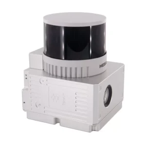
- Sensores integrados: Ele combina um scanner a laser Hesai XT32 de 32 canais, um sistema Geosun gSpin 210 POS (GNSS + IMU) e uma câmera integrada de 2×20 MP (ou 3x5MP, dependendo da variante/série específica).
- Amplo suporte GNSS: A unidade POS suporta vários sinais GNSS, incluindo GPS L1/L2/L5, GLONASS L1/L2, BDS B1C/B1/B2/B2a/B2b/B3 e GALILEO E1/E5b/E5a.
- Taxa de pontuação alta: Ele pode capturar até 1.920.000 pontos por segundo (eco triplo), fornecendo nuvens de pontos densas e detalhadas.
- Amplo campo de visão: O scanner a laser oferece um campo de visão horizontal de 360° e um campo de visão vertical de 270°.
- Software abrangente: Inclui o software de pós-processamento gAirHawk desenvolvido pela Geosun (licença perpétua) para processamento de trajetória e saída de dados de nuvem de pontos em formatos LAS ou TXT personalizados.
- Construção durável: Embalado em uma mala com forro de material EVA, adequado para envio aéreo e marítimo.
Aplicações
O Geosun GS-130G é amplamente utilizado para aquisição de informações espaciais 3D em vários campos, incluindo:
- Topografia e Mapeamento: Mapeamento topográfico, levantamento topográfico e coleta geral de dados 3D.
- Construção de Cidade Digital: Criação de modelos 3D detalhados de ambientes urbanos.
- Silvicultura e Agricultura: Análise de vegetação, estimativa de biomassa e agricultura de precisão.
- Mineração: Levantamento de minas e mapeamento de túneis.
- Patrulha de Linha de Energia: Inspeção e modelagem de infraestrutura de energia.
- Topografia de edifícios: Captura de dados detalhados do interior e exterior do edifício.
- Medição de estoque: Cálculo de volumes de estoques de materiais.
- Preservação do Patrimônio Cultural: Modelagem digital de sítios e artefatos históricos.
Este vídeo da Geosun Navigation apresenta uma solução de mochila leve para os scanners LiDAR GS-100G/120G/130G, demonstrando sua portabilidade e facilidade de uso em trabalho de campo.


Avaliações
Ainda não existem avaliações.