


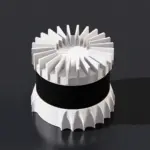
Présentation du produit
Le XT32M1X appartient à la série « XT » (Extended) de Hesai, qui utilise une technologie ASIC (circuit intégré spécifique à une application) propriétaire. Cette conception simplifie le matériel interne, réduisant considérablement le poids et la consommation d'énergie tout en améliorant la fiabilité et la qualité des données par rapport aux capteurs traditionnels à 16 ou 32 canaux.
Sa caractéristique principale est le «Zone sans angle mort» Cette capacité lui permet de détecter des objets même lorsqu'ils sont en contact direct avec le boîtier du capteur, un avantage crucial pour la robotique d'intérieur et les manœuvres d'amarrage.
Caractéristiques principales
-
Haute densité laser : Il est doté de 32 canaux laser, offrant une résolution verticale deux fois supérieure à celle des capteurs standard de milieu de gamme.
-
Plage minimale nulle : Capable d'effectuer des détections valides de 0 m à 120 m, éliminant ainsi l'angle mort typique de 0,5 m que l'on retrouve chez de nombreux concurrents.
-
Précision de niveau topographique : Offre une gamme de précision de 0,5 cm ($1\sigma$) et une précision globale de ±1 cmce qui le rend adapté à la modélisation 3D haute fidélité.
-
Robustesse : Indice de protection IP6K7 et IP6K9K contre l'eau et la poussière, avec une durée de vie opérationnelle testée supérieure à 30 000 heures.
Spécifications techniques
| Fonctionnalité | Spécification |
| Canaux laser | 32 |
| Plage de détection | 0,05 m à 120 m (80 m à réflectivité 10%) |
| Précision de la portée | ±1 cm |
| Précision de la portée | 0,5 cm ($1\sigma$) |
| Champ de vision horizontal | 360° |
| Champ de vision vertical | 31° ou 40,3° (selon la variante du modèle) |
| Résolution angulaire | 0,18° (horizontal) x 1,0° (vertical) |
| Taux de points | 640 000 points/s (retour simple) |
| Retours de données | Jusqu'à 2 (simple/double) |
| Consommation d'énergie | ~10 W |
| Poids | ~800 g |
Applications courantes
-
Cartographie et levés topographiques par drones : Intégrés dans des systèmes comme le Laboratoires inertiels RESEPI pour la création de cartes topographiques et l'inspection des infrastructures.
-
Robots mobiles autonomes (AMR) : Utilisé dans la logistique et les robots de service pour la navigation et l'évitement d'obstacles dans des espaces restreints.
-
Automatisation industrielle : Mesure du volume des stocks ou des cargaisons et surveillance de la sécurité dans les usines intelligentes.
-
Villes intelligentes : Montés sur des véhicules utilitaires ou des poteaux fixes pour la surveillance du trafic routier et piétonnier.
Note: Si vous recherchez la version à plus grande autonomie, vous pourriez être intéressé par le XT32M2X, ce qui étend la portée de détection jusqu'à 300 mètres et est fréquemment utilisé pour la cartographie par drone à haute altitude.


Avis
Il n’y a pas encore d’avis.