

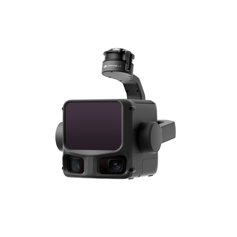
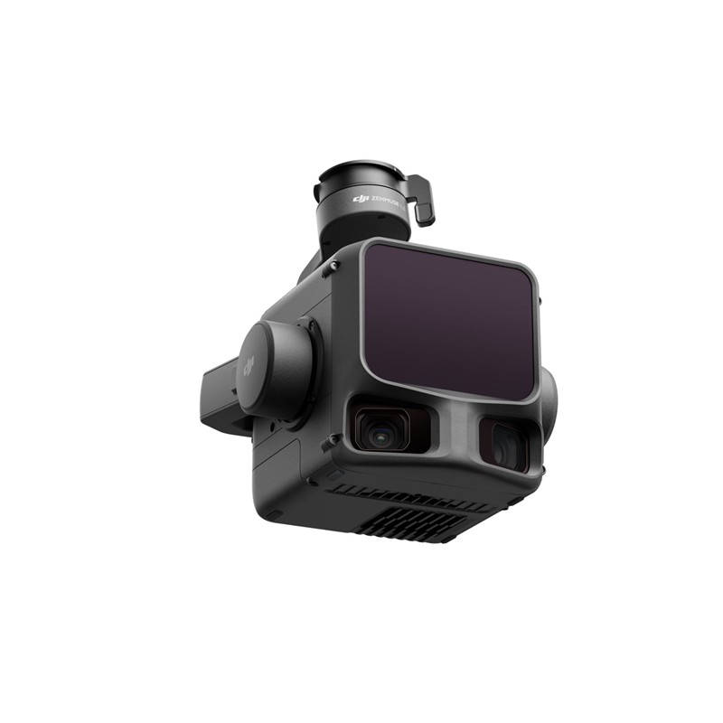
Características principales y rendimiento
- Rendimiento del LiDAR de largo alcance:
- Cuenta con una 1535 nm Clase 1 Sensor LiDAR.
- Excepcional Alcance máximo de detección de hasta 950 metros (en objetos con reflectividad 10%), lo que permite vuelos a gran altitud para una mayor cobertura manteniendo la precisión.
- Penetración superior: Ofrece hasta 16 devoluciones para capturar puntos del terreno más detallados bajo vegetación densa, cruciales para la silvicultura y la cartografía del terreno.
- Precisión ultrafina: Una divergencia de haz láser increíblemente pequeña (0,25 mrad, aproximadamente un tamaño de punto 80% más pequeño que el L2) permite la detección precisa de objetos finos como líneas eléctricas y ramas.
- Sistema de cámara de mapeo RGB dual de 100 MP:
- Integra sensores CMOS Micro 4/3 duales para capturar impresionantes ortofotos de 100 MP (o 25 MP en modo rápido).
- Proporciona un Campo de visión ultra amplio (FOV) de hasta 107° para una cobertura amplia.
- Permite la generación de nubes de puntos de color verdadero y mapas ortofotográficos digitales de alta resolución (DOM).
- Alta precisión y eficiencia:
- Logra precisión a nivel centimétrico (por ejemplo, 3 cm vertical / 5 cm horizontal) cuando se combina con plataformas compatibles con RTK.
- La versión mejorada IMU de alta precisión El sistema permite inicio instantáneo Sin necesidad de precalentamiento.
- Gran eficiencia, capaz de cubrir hasta 100 km² por día.
- Flujo de trabajo continuo:
- Parte de un ecosistema DJI unificado, desde la planificación de vuelo inteligente en Piloto DJI 2 al potente procesamiento de datos en DJI Tierra y edición avanzada en DJI Modificar.
- Admite la captura simultánea de datos LiDAR y RGB desde un único vuelo.
Optimizado para aplicaciones profesionales
La Zenmuse L3 es la herramienta definitiva para profesionales en:
- Levantamiento topográfico y geomática: Realizar levantamientos a escala 1:1000 con una eficiencia inigualable.
- Inspección de infraestructura: Modelado e inspección precisos de activos como líneas eléctricas y puentes.
- Silvicultura y monitoreo ambiental: Modelado preciso de las capas de la cubierta vegetal y del terreno bajo una densa cobertura.
- Minería y extracción de canteras: Calcular eficientemente los volúmenes y supervisar los cambios en el sitio.
La Zenmuse L3 garantiza que los profesionales puedan capturar datos geoespaciales de forma más rápida, profunda y precisa, optimizando los flujos de trabajo y reduciendo los costes operativos.
Compatibilidad
DJI Matrice 400 (requiere conector de gimbal único Zenmuse L3)
Contenido
1x DJI Zenmuse L3
1 conector de cardán individual Zenmuse L3
1 estuche de almacenamiento
4x amortiguadores de cardán
2 tarjetas de memoria CFexpress tipo B
1 lector de tarjetas CFexpress tipo B


Valoraciones
No hay valoraciones aún.