


Características y tecnología clave
- Tecnología SLAM integrada: Incorpora algoritmos SLAM de nivel industrial, que permiten un posicionamiento y mapeo precisos y sin interrupciones en áreas donde las señales GNSS son débiles o no están disponibles (por ejemplo, en interiores, túneles, cañones urbanos densos).3 Es compatible con ambos Slam puro y RTK-SLAM fusión.
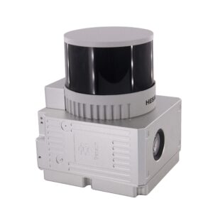
- Captura de datos de alta densidad: Equipado con un Sensor LiDAR giratorio de 32 canales (a menudo la Hesai XT32), el sistema captura hasta 1.280.000 puntos por segundo (eco dual), lo que garantiza una representación densa y fiable del entorno escaneado.
- Amplio campo de visión (FOV): Ofrece un amplio rango de escaneo con un 360° horizontales y 270° vertical campo de visión, minimizando los puntos ciegos y maximizando la cobertura con el mínimo esfuerzo.
- Nube de puntos coloreada en tiempo real: La cámara RGB de alta definición integrada (normalmente 3 x 5 MP resolución) permite la captura de datos de nube de puntos coloreados en tiempo real, proporcionando un rico contexto visual para facilitar la interpretación de datos y el modelado 3D.
- Alta precisión: Logra un Precisión absoluta de 5 cm y un Precisión relativa de 1,5 cm, garantizando datos de calidad de nivel de encuesta.
Versatilidad y diseño
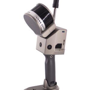
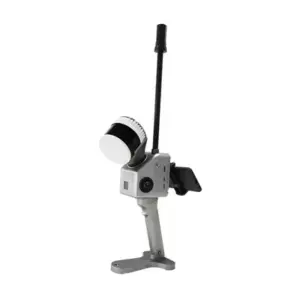
- Funcionamiento multiplataforma: El GS-120G presenta un diseño minimalista y flexible, lo que permite su montaje en múltiples plataformas, incluyendo:
- Portátil (modo primario)
- Mochila
- Aerotransportado (Carga útil del UAV/dron)
- Vehículo
- Sistema de posicionamiento robusto: Incorpora un sistema de navegación inercial (INS) de alto rendimiento y un módulo GNSS multiconstelación (GPS, GLONASS, BDS, GALILEO), lo que garantiza una precisión a nivel de centímetros cuando hay señales de satélite disponibles.
- Flujo de trabajo fácil de usar: Presenta un diseño minimalista y un cuerpo ligero (15$ ≈ 2,2 kg $), e incluye software de procesamiento de datos con un solo clic (por ejemplo, PointCreator) y una aplicación móvil intuitiva para la vista previa de nubes de puntos en tiempo real.
Resumen de especificaciones técnicas
| Especificación | Detalle |
| Canales láser | 32 líneas |
| Alcance máximo | 120 metros |
| Tasa de puntos | Arriba a 1.280.000 puntos |
| Precisión absoluta | 5 cm |
| Peso (con batería) | aproximadamente 2,2 kg |
| Compatibilidad con GNSS | Constelación completa (GPS, GLONASS, BDS, GALILEO) |
| Almacenamiento de datos | 128GB Tarjeta SD |
| Tiempo de funcionamiento | aproximadamente 2 horas (Batería interna) |
Aplicaciones ideales
El Geosun GS-120G es una herramienta indispensable para profesionales en:
- Modelado de información de construcción (BIM) y Levantamiento topográfico de obra terminada
- Levantamiento topográfico y Modelado digital
- Cartografía de garajes y túneles subterráneos
- Medición del volumen de acopio
- Estudio minero y Inspección de infraestructura
El GS-120G permite a los usuarios capturar rápidamente datos 3D georreferenciados precisos, revolucionando los flujos de trabajo de topografía y cartografía.


Valoraciones
No hay valoraciones aún.