


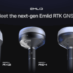
Reach RS4 and Reach RS4 Pro: powerful and future-ready
The Reach RS4 and RS4 Pro receivers mark a major evolution from the previous Reach models. They offer uncompromised precision in any condition and quicker workflows than ever before. The Reach RS4 Pro stands out with its innovative camera-vision technology, which redefines traditional RTK and cuts down on survey time.
The key features include:
- All-band RTK reception (L1/L2/L5/L6) across all satellite systems for unparalleled performance in urban canyons, dense canopies, and other difficult conditions.
- Integrated antenna system with diversity LTE, dual-band Wi-Fi, and Bluetooth for a clean GNSS signal and stable fix solution wherever you go.
- Emlid multi-band radio system up to 2W, interoperable with third-party gear for sending and receiving corrections. The radio supports both licensed and license-free operations at 450 MHz and 915 MHz. This allows users to adapt to project needs while staying compliant with regulatory requirements.
- Next-generation IMU tilt compensation with up to 5 times faster initialization.
- Durability-first design with a magnesium alloy body, IP68 protection, and user-replaceable bumpers to secure the receiver from the scariest falls.
- Made for iPhone certification for compatibility with iOS apps, including Esri ArcGIS apps.
- Innovative quick release mount for a survey pole, ensuring accuracy and speed, even when tilted. Сompatible with standard 5/8” thread.
Reach RX2: compact and reliable
The Reach RX2 is an ultra-portable RTK rover that is simple to use, with no settings to configure. Building on the strengths of the previous Reach RX, the new model is enhanced with greater performance in obstructed areas and new IMU tilt compensation. The new features include:
- All-band RTK support (L1/L2/L5/L6) for greater reliability under canopy or in urban areas.
- Second-generation IMU tilt compensation for accurate, level-free measurements.
- The quick release mount for a fast and reliable setup in the field.
Pocket-sized and easy to deploy, the Reach RX2 is ideal for GIS, construction, and asset management in companies running multiple projects and teams. It integrates seamlessly with Esri ArcGIS apps for GIS data collection, and with the Pix4Dcatch app for mobile terrestrial scanning.


Reviews
There are no reviews yet.