


CAPTURE
Capture images or point clouds with a drone or any laser scanner.
When using a drone, automate and optimize your flights with the free Pix4Dcapture mobile app.
MODEL
Transform your images into digital point clouds, and import them into Pix4Dsurvey.
Work directly with Pix4Dmapper or Pix4Dmatic files, as well as any .las or .laz file.
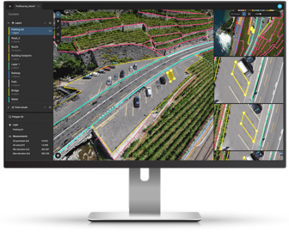
VECTORIZE
Generate a TIN to model the ground and create engineering-ready CAD vector files from point cloud data by extracting key elements of your project with Pix4Dsurvey.
INTEGRATE
Open your simplified, accurate data in any CAD or GIS software with custom layers and properties that fit your existing workflow.


Reviews
There are no reviews yet.