


Key features
- Multi-constellation GNSS Post-Processing: REDtoolbox can process data from multiple Global Navigation Satellite Systems (GNSS) constellations, including GPS, GLONASS, Beidou, and Galileo, to improve accuracy.
- PPK for Base-Rover Configurations: It excels at post-processing kinematic (PPK) data collected with a base-rover configuration, commonly used in high-precision drone mapping applications.
- Geotagging of Images: The software can georeference captured images, assigning accurate location data to each photo. This is crucial for creating precise 3D models from drone imagery.
- Multiple Device Compatibility: REDtoolbox works with data from a wide range of devices and chipsets from popular drone manufacturers like DJI, Autel, Yuneec, and Emlid, making it a versatile tool.
- Automated Workflow: The program boasts a user-friendly interface with a highly automated workflow. Complex tasks like geotagging and data processing can often be accomplished with just a few clicks.
- Support for Multiple Projects: REDtoolbox efficiently handles projects consisting of multiple flights or capture sessions.
Overall, REDcatch REDtoolbox is a valuable software solution for professionals working with drones and terrestrial devices who require accurate geospatial data.
Compatible drones and devices of REDtoolbox software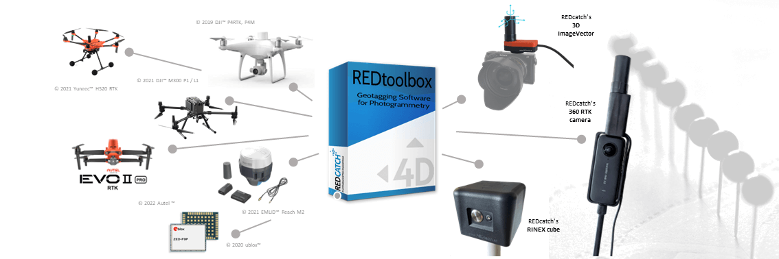
Use the output directly in your photogrammetry software
Outputted as plain Text, as image EXIF data or in native Agisoft Metashape Professional, Pix4d Mapper, Pix4d Matic, Shape file and Google Earth kml, these information can be used directly witouht any additional converting.
Applications., eg. in photogrammetry and documentation.


Reviews
There are no reviews yet.