


Key Features and Functionality
1. Surveying and Data Processing
The Surveying Module provides essential tools for initial data processing:
- Total Station and GNSS Data: Imports and processes observations from total stations and GNSS (GPS/GLONASS) receivers.
- Coordinate Transformations: Performs both global and local coordinate transformations, including the EPSG database of reference systems organized by country.
- Geodetic Calculations: Calculates point coordinates, and adjusts traverses and networks for accurate spatial positioning.
2. Digital Terrain Modeling (DTM) and Earthworks
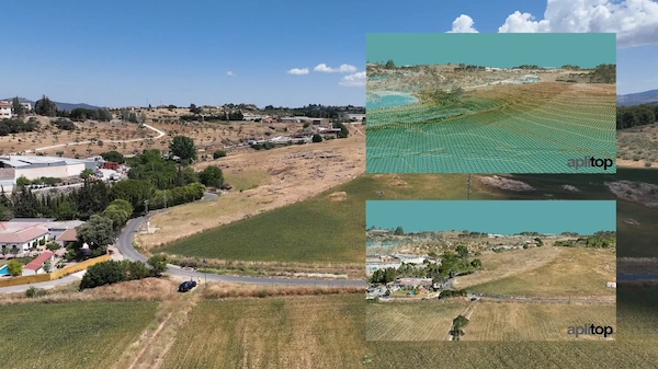
- Terrain Modeling: Creates, edits, and analyzes Digital Terrain Models (DTMs) from measured points or point clouds.
- Visualization and Analysis: Generates contour lines, slope maps, shadow maps, elevation maps, and visibility maps. Includes a realistic 3D rendering and virtual reality viewer.
- Volume Calculation: Performs cut and fill volume calculations between surfaces, including calculations for stockpiles.
- Advanced Earthworks: Features for defining project cross-sections (platforms, ditches, slopes, pavement layers) for complex grading and esplanades.
3. Civil Engineering Design
- Alignment Design: Tools for designing both horizontal and vertical alignments for roads, railways, and other linear infrastructure.
- Cross-Sections and Templates: Defines and draws project cross-sections/templates and their components.
- Network Design: Tools for drawing and designing utility networks, including water, sanitation, and rainwater networks, with representation in top view, profile, and cross-sections.
4. Reporting, Stakeout, and Integration
- Reporting: Generates detailed reports on area and volume measurements, budgets, quantity take-offs, and more.
- Stakeout: Comprehensive tools for generating stakeout listings for isolated points and linear projects.
- BIM and GIS Integration: Facilitates integration into OpenBIM workflows through the exchange of industry-standard files like IFC and LandXML. It also supports importing and exporting GIS data and accessing web map services.
- Virtual Tour: Includes a virtual tour feature with export to video.
This software is suitable for a diverse range of projects, including roads, urban developments, quarries, mining, environmental assessments, and utility infrastructure.


Reviews
There are no reviews yet.