


Key Features and Capabilities
- Long-Range and High-Precision Laser Scanner: At its core is the FT-800 laser scanner, offering an impressive maximum detection range of up to 1500 meters (at 80% reflectivity) and a measuring accuracy of 5mm at 100 meters. This capability allows for efficient data collection over large areas and at varying altitudes.
- Integrated AGS 303 POS System: The GS-1500N leverages the Geosun AGS 303, a high-performance GNSS (Global Navigation Satellite System) and IMU (Inertial Measurement Unit) system. The AGS 303 ensures highly accurate real-time or post-processed positioning and orientation data, crucial for generating precisely geo-referenced point clouds. It offers a heading accuracy of 0.017°, pitch/roll accuracy of 0.005°, and horizontal position accuracy of 0.05m, with a 200Hz update frequency.
- High Point Rate and Multiple Echoes: The system captures incredibly dense point cloud data with a point rate of up to 1,500,000 points per second and support for up to 5 echoes. This rich data is essential for creating detailed terrain models, extracting precise object information, and conducting in-depth analyses.
- Built-in RGB Camera: The GS-1500N typically includes a high-resolution 26MP or 45MP full-frame RGB camera (often with a 16mm focal length). This camera provides valuable color information that can be fused with the LiDAR point cloud, enabling the creation of realistic 3D models and enhancing data interpretability.
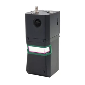
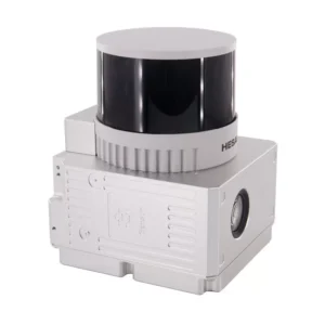
- Robust and Compact Design: Housed in a durable aluminum alloy shell, the GS-1500N is designed for resilience in various field conditions. Its lightweight (approximately 2.2kg – 2.5kg) and compact dimensions make it highly compatible with popular drone platforms such as the DJI Matrice 300/350 RTK and Yuneec H850RTK, as well as VTOL aircraft and other vehicle integrations.
- Comprehensive Software Workflow: Geosun provides a complete software suite, including dedicated POS software for trajectory processing and gAirHawk Post-processing software (often with a perpetual license). This streamlines the data processing workflow, allowing for the output of point cloud data in industry-standard formats like LAS and custom TXT.
- Wide Range of Applications: The GS-1500N (AGS 303) is a versatile tool for acquiring 3D spatial information across numerous sectors, including:
- Surveying and Mapping: High-precision topographic mapping, cadastral surveys, and urban planning.
- Forestry: Biomass estimation, tree health monitoring, and forest inventory.
- Agriculture: Precision farming, crop health assessment, and irrigation planning.
- Power Line Inspection: Detailed mapping of power line corridors for maintenance and planning.
- Digital City Construction: Creating accurate 3D models of urban environments.
The Geosun GS-1500N (AGS 303) offers a powerful combination of long-range scanning, high-precision positioning, and robust data acquisition, making it an ideal solution for professionals requiring accurate and detailed geospatial insights.


Reviews
There are no reviews yet.