


Key Features and Technology
- Integrated SLAM Technology: Features industry-grade SLAM algorithms, allowing for seamless and accurate positioning and mapping in areas where GNSS signals are poor or unavailable (e.g., indoors, tunnels, dense urban canyons).3 It supports both Pure SLAM and RTK-SLAM fusion.
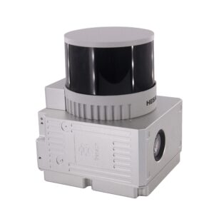
- High-Density Data Capture: Equipped with a 32-channel rotating LiDAR sensor (often the Hesai XT32), the system captures up to 1,280,000 points per second (dual echo), ensuring a dense and reliable representation of the scanned environment.
- Wide Field of View (FOV): Offers an extensive scanning range with a 360° horizontal and 270° vertical field of view, minimizing blind spots and maximizing coverage with minimal effort.
- Real-Time Colored Point Cloud: The integrated high-definition RGB camera (typically 3 x 5 MP resolution) allows for the capture of real-time colored point cloud data, providing rich visual context for easier data interpretation and 3D modeling.
- High Accuracy: Achieves an Absolute Accuracy of 5cm and a Relative Accuracy of 1.5cm, ensuring survey-grade quality data.
Versatility and Design
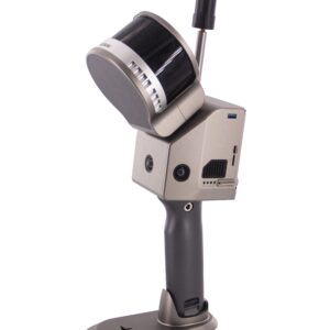
- Multi-Platform Operation: The GS-120G features a minimalist and flexible design, allowing it to be mounted on multiple platforms, including:
- Handheld (primary mode)
- Backpack
- Airborne (UAV/Drone payload)
- Vehicle
- Robust Positioning System: Incorporates a high-performance Inertial Navigation System (INS) and multi-constellation GNSS module (GPS, GLONASS, BDS, GALILEO), ensuring centimetre-level accuracy when satellite signals are available.
- User-Friendly Workflow: Features a minimalist design, lightweight body (15$\approx 2.2\text{kg}$), and includes one-click data processing software (e.g., PointCreator) and an intuitive mobile App for real-time point cloud preview.
Technical Specifications Summary
| Specification | Detail |
| Laser Channels | 32-Line |
| Max Range | 120m |
| Point Rate | Up to 1,280,000 points |
| Absolute Accuracy | 5cm |
| Weight (with Battery) | approx 2.2kg |
| GNSS Support | Full Constellation (GPS, GLONASS, BDS, GALILEO) |
| Data Storage | 128GB SD Card |
| Operating Time | approx 2 hours (Internal Battery) |
Ideal Applications
The Geosun GS-120G is an indispensable tool for professionals in:
- Building Information Modeling (BIM) and As-Built Surveying
- Topographic Survey and Digital Modeling
- Underground Garage and Tunnel Mapping
- Stockpile Volume Measurement
- Mining Survey and Infrastructure Inspection
The GS-120G empowers users to quickly capture precise, georeferenced 3D data, revolutionizing surveying and mapping workflows.


Reviews
There are no reviews yet.