


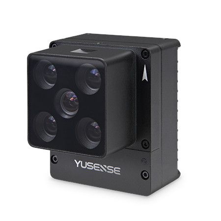
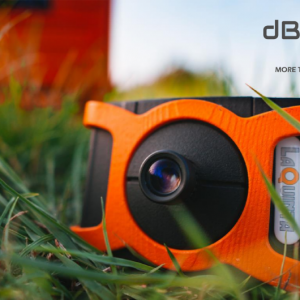
Product features
- 6 multispectral bands
- 1.2 Megapixel
- 12bit global shutter
- Ethernet/TTL serial port
- On-camera real-time reflectance calculation
- Synchronized imaging of all channels up to 1s
- Downlink Light Sensor (DLS) as standard
- ≤10W@12V power supply, 64G TF card
- Multiple trigger modes: external, timed, and overlap rate
- Compatible with multiple rotary and fixed-wing UAV platforms
- Precision agriculture: Crop health monitoring, pest and disease detection, optimizing resource management.
- Environmental monitoring: Water quality analysis, pollution detection, land cover change assessment.
- Resource exploration: Mineral mapping, soil analysis, vegetation classification.
- Search and rescue: Identifying objects and personnel in challenging environments.
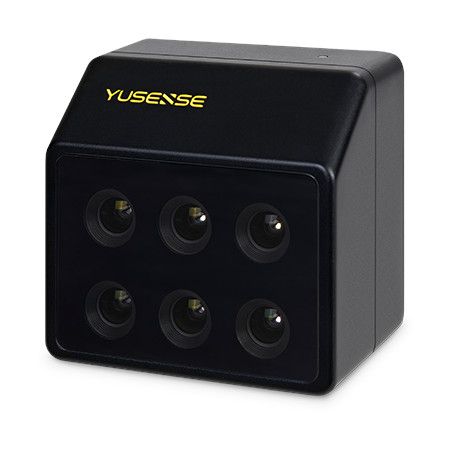
Key features of the MS600 V2:
- Six spectral bands: Capture information in blue, green, red, red-edge (2 bands), and near-infrared wavelengths.
- 1.2 megapixel resolution: Delivers detailed and accurate images for precise analysis.
- Global shutter: Eliminates image distortion caused by rolling shutter effects, crucial for aerial photography.
- Downwelling light sensor (DLS): Measures ambient light conditions for improved data accuracy and post-processing.
- Built-in GPS: Records camera position and attitude in image metadata for advanced analysis.
- Fast imaging speed: Enables efficient data collection over large areas.
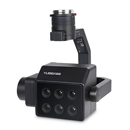
- Easy integration: Compatible with various JOUAV drone platforms and supports DJI X-Port interface.
Benefits:
- Enhanced decision-making: Provides richer data compared to traditional RGB cameras, leading to better-informed decisions.
- Improved efficiency: Streamlines tasks like crop monitoring and resource exploration.
- Cost-effective solutions: Offers valuable insights at a competitive price point.
Overall, the Yusense MS600 V2 is a versatile and powerful multispectral camera for professionals seeking to unlock the invisible spectrum and gain deeper understanding in various fields.
Additional considerations:
- While specific pricing information is limited, the MS600 V2 targets professional users and businesses.
- Yusense offers dedicated software (Yusense Map) for efficient multispectral image processing.
- It’s recommended to check compatibility with your specific drone platform before purchase.
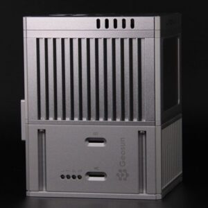
Technical parameters
- Configuration: 6 multi-spectral channels
- Target size: 1/3″
- Effective pixel: 1.2 Mpx
- Shutter type: global
- Quantization bit: 12bit
- Field of View: 49.5°×38.1°
- Ground resolution: 8.65cm@h120m
- Coverage width: 110m×83m@h120m
- Spectral channel [1] 450nm@30nm,555nm@27nm, 660nm@22nm,720nm@10nm,7 50nm@10nm, 840nm@30nm
- Optical Window: Sapphire Optical Glass Window
- Dimensions: ≤80mm×75mm×55mm
- Weight: ≤280g
- Mounting interface: 4×M3
- Power supply: 12V (please consult Yuchen marketing staff for other voltage supply)
- Power Consumption: ≤10W@12V
- Picture format: 16bit original TIFF & 8bit reflectivity JPEG (including GPS, ambient light information)
- Video Format
- Storage media: Standard 64G, maximum support 128G capacity (transfer speed U3 and above rating) micro SD card
- Processing Software: Yusense Map/Yusense Map Plus
- Parameter settings: WIFI (WEB interface access)/UART
- Shooting Trigger: External Trigger, Timer Trigger, Overlap Rate Trigger, Cascade Trigger
- Shooting frequency: 1Hz (related to the actual read/write speed of storage media)
- Working environment temperature: -10℃~+50℃(relative wind speed≥1m/s)
- Storage Ambient Temperature: -30℃~+70℃
- Ambient Humidity: RH(%)≤85%(non-condensing)
- Product Certification: CE, FCC, RoHS
Applications
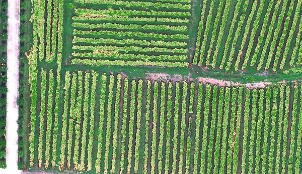
Vegetation growth assessment
Using NDVI, LAI and other vegetation factors, we quantitatively describe the consistency of the vegetation canopy state at different spatial scales, assist the characteristic spectra of vegetation in different health states, quantitatively assess the vegetation’s longevity, and provide data support for irrigation, fertilizer application, plant protection, and yield assessment.
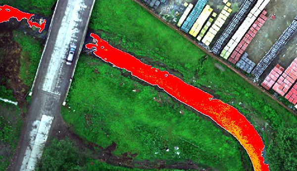
Monitoring of black-odor water bodies
With reference to the evaluation standard of surface black smelly water bodies, we use characteristic spectra to construct classification indexes, realize graded inversion and spatial information statistics of black smelly water bodies, assist in analyzing the impact of domestic sewage and industrial wastewater on the surrounding water bodies, and help in the investigation of pollution sources and assessment of the water environment.
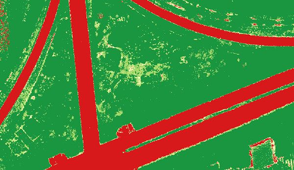
Coverage Assessment
Based on the fingerprint spectrum of vegetation to construct vegetation index, complete the spatial distribution and area statistics of the target vegetation in the designated area, and provide quantitative data on vegetation cover for scientific research and production in agriculture, forestry and grassland, ecology and other fields.
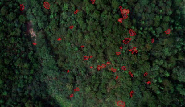
Monitoring of pine discolored standing trees
Comprehensively utilizing spectral and texture information to realize efficient suppression of environmental backgrounds such as soil, dead grass and high-precision identification of discolored standing trees, accurately extracting information on the location, spatial distribution and canopy area of the discolored standing trees, and providing data support for the management of infected trees.


Reviews
There are no reviews yet.